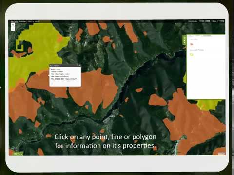
 Digital Basin Quick Start

Despite the size of the Basin-Boundary population remaining relatively constant at the regional scale over the period 2011-2015, individual areas saw greater variability. A population increase was reported for eleven of 28 municipalities, with Nelson leading at 4%. The Basin-Boundary population as a whole is projected to grow by about 7500 residents over the next 20 years, … [More]
RDI Releases 2015 State of the Basin Report
December 7, 2015
Did you know that building activity and business counts are both on the rise in our region? Or that almost 14,000 hectares burned during the latest wildfire season? These issues and many more are explored in the Rural Development Institute’s 2015 State of the Basin Snapshot Report. The State of the Basin initiative is an indicator monitoring program that reports on … [More]
2015 Trends Analysis: Wildfire
November 17, 2015
2015 was a notable fire year in the Basin-Boundary region, with over 13,800 total hectares burned. The biggest fires were located near Rock Creek (4417 ha) and in the Granby River drainage (1686 ha). A ten-year moving average of total area burned in the region shows that, on average, the impact of fire on our region continues to be much lower as compared to the years preceding … [More]
2015 Trends Analysis: Air Quality
November 5, 2015
As compared to 2013, compiled 2014 air quality data for stations in our region show higher particulate matter readings in the summer, and lower readings in the winter. The Nelson station continues to record the lowest fine particulate matter readings of all Basin-Boundary stations. For our full discussion of air quality trends and conditions, download the 2015 Air Quality … [More]

 Basin-Boundary Agricultural Planning: The Regional Perspective